Frequently asked questions
what we know, in a bit more detail
Clear answers about the proposed sale, planning, public access and what Friends of Lower Field is doing next.
This FAQ consolidates information already in the public domain. Anyone with information that meaningfully supplements it or corrects an unintentional error can provide that information through the survey.
Last updated 15 September 2026
The sale
Has Lower Field already been sold?
No. The Land Registry title documents show that the land is still owned by Education South West, the academy trust which KEVICC joined when it transferred to academy status in September 2022.
The land has been offered for sale and Education South West has permission from the Department for Education to dispose of it, but no sale has been completed.
What exactly is proposed for sale?
Only Parcels E and F(1) shown on the marketing plan are being offered for sale.
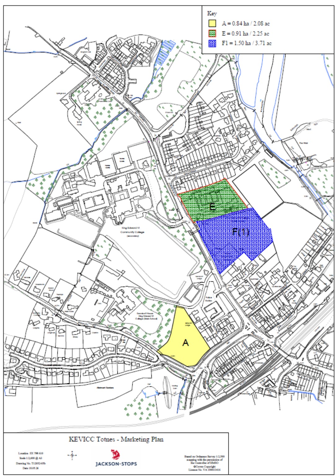
The proposed sale comprises the fenced-off school building, surrounding hardstanding and car park, together with part of Lower Field extending down towards the all-weather pitch.
Parcel E is approximately 0.91 hectares or 2.25 acres. Parcel F(1) is approximately 1.50 hectares or 3.71 acres. Together, the marketed land amounts to about 2.41 hectares or 5.96 acres.
The grass closest to the River Dart, the all-weather pitch and the rugby pitch are not included in the proposed sale.
The land on which the all-weather pitch sits is owned separately by Dartington Hall Trust and leased to Education South West.
Has the government approved the sale?
Yes. In February 2025, the Department for Education approved Education South West's application to dispose of playing-field and non-playing-field land.
The published decision describes the proposal as a rationalisation of the school site while retaining sufficient playing-field provision, with proceeds used to improve facilities at the school, including sports facilities. Education South West therefore has the necessary Department for Education consent to dispose of the land.
Very little of the underlying application, assessment and supporting evidence is publicly available. Friends of Lower Field is seeking that material so we can understand exactly what was proposed, what commitments formed part of the approval and whether the approved process is being followed.
So is a sale now a done deal?
No. Department for Education approval removes one important barrier to disposal, but it does not mean a sale has already happened.
Other matters could affect what ultimately happens to the site, including the Asset of Community Value process, planning policy, public rights of way and the possibility of a community bid. These are all being investigated.
Why is Education South West selling the land?
The Department for Education approval describes the proposal as a rationalisation of the school estate, with proceeds intended to improve school facilities, including sports facilities.
There are still important unanswered questions about the financial case for the disposal, the precise commitments made about replacement provision required by the Joint Local Plan and how the proceeds would be used. Obtaining the full Department for Education application is therefore one of the campaign's current priorities.
Why are we asking for the full Department for Education disposal pack?
Because the short published approval does not tell the whole story. The full application should help establish:
- exactly what land Education South West asked permission to sell;
- what valuation and marketing information was provided;
- how the Trust said the proceeds would be used;
- what was proposed for replacement or improved facilities;
- what was said about community use and access;
- whether there were commitments around parking or other infrastructure; and
- what conditions, if any, the Department for Education attached to its consent.
Until we see those documents, several important questions about the sale remain unanswered.
What does the Asset of Community Value status mean?
Lower Field is currently listed as an Asset of Community Value. The existing five-year listing expires on 5 November 2026.
Education South West notified South Hams District Council of its intention to dispose of the land in May 2026. Phoenix TEK Services CIC, NDP Circus and Ethical Sustainable Properties CIC registered an interest together, triggering a six-month moratorium on a sale to a commercial buyer.
The six-month moratorium runs until 5 November 2026. During that period, the process gives any community interest, not only the three organisations which triggered it, an opportunity to organise around a potential bid.
Asset of Community Value status does not require the owner to sell to the community or give the community a right of first refusal. After 5 November 2026 there is a one-year protected period during which the owner is free to sell to whomever it chooses. A fresh Asset of Community Value nomination can be made after that protected period ends on 5 November 2027.
Could the community buy the land?
Yes. Although the Asset of Community Value listing does not give the community first refusal, a community organisation, the Town Council or another suitable body could seek to become a serious or preferred bidder.
No community purchase proposal has yet been agreed. Important questions remain about the structure of a bid, the price of the land and the funding that could be assembled. The campaign is examining what would need to be in place for a credible community bid to become possible.
Does Education South West have to accept the highest offer?
This is open to interpretation. The Trust is expected by the Department for Education to show that the disposal represents best value. In practice, that means achieving the best price reasonably obtainable, supported by proper valuation and open marketing.
That does not necessarily mean simply accepting the highest offer. The Trust would need to assess any accompanying social value and justify a decision to accept a lower financial offer.
A community organisation could still make an offer, but it would need a serious and competitive proposal capable of satisfying the Trust's obligation to achieve best value.
Are there legal covenants protecting the field for community use?
The Elmhirst family played an important part in the history of the school and its land, but we have not yet established that the land being sold was legally gifted to the community or permanently protected for community use.
There is an important distinction between land being given for educational or community purposes and legal documents containing an enduring restriction on its future sale or use.
We are examining the historic conveyances, title documents, covenants and other agreements to determine:
- who originally provided the land;
- what purposes it was provided for;
- whether any restrictions still apply; and
- whether the community was given any lasting legal rights.
Until that work is complete, we cannot say categorically either that the land was definitely gifted to the community or that no historic restrictions exist.
Planning and development
Does permission to sell mean permission to build houses?
No. Department for Education consent to dispose of school land is separate from planning permission.
A purchaser wanting to develop the land would still need to go through the planning system. An allocation in planning policy does not itself grant planning permission for a particular scheme.
Could the field be protected through the planning system?
There are several possible planning routes.
The adopted Joint Local Plan, through policy TTV20, allocates the site for residential-led development of around 130 homes. However, the policy also requires replacement of the all-weather sports pitch, community facilities, public space alongside the River Dart, continuous riverside access, safe walking and cycling connections, high-quality development, a bat mitigation plan relating to the South Hams Special Area of Conservation and an A385 air-quality mitigation strategy.
South Hams and West Devon are developing a new Joint Local Plan. A consultation is open until 24 September 2026 and is currently at the scoping stage, before site allocations have been identified.
The campaign is considering whether stronger protection can be secured through that process, including Local Green Space designation and clearer safeguards for community sport, open space and parking.
Why is the new Joint Local Plan important?
The new plan provides an opportunity to argue for stronger protection of Lower Field before the detailed site allocations are settled.
The campaign is considering proposals to protect more of the lower part of the field, secure continued use by local sports teams, protect or replace parking associated with the shared-use all-weather pitch, strengthen requirements for public open space and access, and seek Local Green Space designation.
What is Local Green Space designation?
It is a planning designation that can give locally important green spaces significant protection from development.
The campaign is examining whether Lower Field could qualify under the relevant National Planning Policy Framework criteria. No decision has yet been made on whether an application would succeed.
Could Lower Field become a Town or Village Green?
At present, the campaign believes this route is unlikely to succeed.
The site's existing housing allocation in the adopted local plan appears to be a statutory trigger event. This would prevent a Town or Village Green application while the allocation remains in place.
We are continuing to check the available options before treating the route as definitively closed. This does not prevent the separate application to have the long-used public footpath formally recognised.
Could development be stopped altogether?
We do not yet know. The existing housing allocation is an important constraint, so it would be misleading to promise that development can simply be prevented.
The campaign is therefore examining both routes that might strengthen protection for the land and safeguards that could be secured if some development ultimately takes place.
If development happens, could community access and facilities still be protected?
Potentially, yes. Existing policy already requires public space alongside the River Dart, continuous riverside access, replacement sports provision and community facilities.
The campaign wants these requirements to be clearer and stronger, particularly around informal recreation, continued use by local sports teams, access and suitable parking for the shared-use sports facilities.
What happens if a planning application is submitted?
A planning application would begin a separate public process. Friends of Lower Field would review the proposal against the relevant planning policies and publish clear information about matters affecting community interests, including access, transport, flood risk, ecology, sport and community facilities.
Information submitted through the survey will help the campaign understand how the site is used and what matters to local people when preparing its response.
What can people do about planning now?
The immediate opportunity is the emerging Joint Local Plan consultation, which closes on 24 September 2026. The campaign is preparing its own response.
Please use the survey to tell us how you use Lower Field and what matters to you about its future. This will help the campaign identify the strongest points to raise.
Public access and the claimed footpath
Is there currently a recorded public right of way across Lower Field?
No. The route we are seeking to have recognised is not currently recorded as a public footpath on Devon's Definitive Map, so its future cannot be taken for granted.
Long-standing public use may provide grounds for a Definitive Map Modification Order. This requires evidence that a specific route has been used by the public for at least 20 years as of right, meaning openly and without force, secrecy or permission.
What route are Friends of Lower Field trying to protect?
We have identified the route that will form the basis of the claimed public footpath application.
The route is shown on our Schedule 14 Application Plan as A-B-C-D-E-F, crossing Lower Field from the western side of the site towards the River Dart.
The survey is gathering evidence from people who have used this particular route, especially over many years. We need to establish how long and how regularly it was used, and whether that use was open, without permission and without being stopped.
What evidence is useful for the right-of-way claim?
Evidence of people using the identified route over a long period is particularly important. Useful material can include:
- witness evidence;
- old photographs;
- historic maps or aerial imagery;
- Strava or other activity records; and
- other documents showing people using the route over time.
Does sporting use of the field count?
Not necessarily. For a historic right-of-way claim, the relevant use must have been as of right. Use which took place with the landowner's permission may not count in the same way.
The survey separates use of the specific claimed route from wider sporting and recreational use so that each type of evidence can be considered properly.
What are the new signs and the 2026 landowner deposit intended to do?
On 20 May 2026, Education South West made a landowner deposit under section 31 of the Highways Act and put up notices at the field entrance.
The purpose of a deposit is to make clear that the landowner does not intend new public rights of way to arise through future use. The campaign understands this to be the first such deposit relating to this land.
It does not automatically determine whether rights had already arisen through earlier long-term public use. This is why evidence from before the deposit is particularly important.
Is there another way to create a public footpath?
Yes. The campaign is also examining a public path creation order under section 26 of the Highways Act.
That route is based more on demonstrating a practical or strategic community need for a path than on proving 20 years of historic use. The two possible routes are being considered separately.
Can development still happen if the footpath is recognised?
Yes. Recognition of a public right of way would not necessarily prevent development of the surrounding land.
However, a recognised public footpath would have legal status and could not simply be ignored. Any development proposal affecting it would need to deal with the route lawfully.
The campaign and what happens next
What is Friends of Lower Field trying to achieve?
The campaign has deliberately not fixed on a single outcome before the facts are clear. Its common aim is to secure the best possible outcome for the field and the wider community while keeping the available options open.
Work is progressing across:
- public rights of way and evidence of historic use;
- planning protections, including the emerging Joint Local Plan and Local Green Space designation;
- scrutiny of the Department for Education land-disposal process;
- community ownership and the Asset of Community Value route;
- public communications and engagement; and
- relationships with councils, elected representatives and other partners.
What can I do now?
The most useful immediate action is to complete the survey. It records use of the whole site and the specific claimed route, and allows photographs, activity records, maps and other supporting material to be uploaded in the same place.
Long-term evidence is especially important for the public-right-of-way application, but recent use also helps show how Lower Field is used today and what people value about it.
Where can I find reliable updates?
Friends of Lower Field is establishing a clear public information hub so people do not have to piece together facts from individual messages.
Updates will distinguish between established facts, matters still being investigated and campaign proposals. This FAQ will be updated as further documents and evidence become available.